The Great Smoky Mountains are legendary. Straddling the border between Tennessee and North Carolina, they are part of the Blue Ridge Mountains and the Appalachian Mountain range. In fact, the famous Appalachian Trail crosses through the national park on its way from Georgia to Maine.
If you love hiking, Great Smoky Mountains is a paradise. The park has plenty of amazing hiking trails, including some that either form part of the Appalachian Trail or branch off it.
Hikes go to waterfalls, end at summits with breathtaking views or cross babbling brooks. No matter what you love to see on a hike, there is something for you in the Smokies.
Subscribe to daily national parks planning tips, travel inspiration and trip ideas and get instant access to the free PDF of this
Best Hikes in Great Smoky Mountains National Park
No time to read about the best hikes in Great Smoky Mountains National Park now? Pin It and save it for later:
🛏️TOP HOTEL PICK: Check availability now
🚘FIND THE CHEAPEST CAR RENTAL: Search Discover Cars for the best deals
✈️FIND THE CHEAPEST FLIGHTS: Search Skyscanner for the best deals
🧳GET TRAVEL INSURANCE: Get insured with Travelex before you go
📱TAKE AN AUDIO TOUR: Buy an audio tour now
Table of Contents
Best Hikes In Great Smoky Mountains National Park
If you’re planning to visit the area and are wondering what the best hikes in the Smokies are, this list is for you. I have, with the help of some fellow travel experts, compiled a shortlist of the best hikes in Smoky Mountains National Park. They range from easy to difficult, so there is something for everyone.
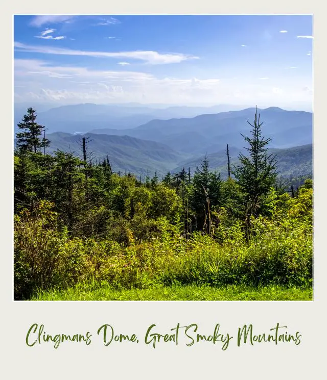
1. Kuwohi (formerly called Clingmans Dome)
Length: 1.2 miles | 1.9 km roundtrip
Difficulty: Moderate (it’s short, but steep)
Trailhead: Kuwohi (Clingmans Dome) Trailhead, at the end of Clingmans Dome (Kuwohi) Road. The turnoff is 0.1 mile south of Newfound Gap
A strong contender for the best hike in Smoky Mountains, the hike up Kuwohi may be short, but it has several other unique characteristics that make it a must see! This point-to-point trek is entirely uphill from the trailhead to the summit, making it a surprisingly worthy challenge!
At its summit, you will discover not only some of the most breathtaking views of the Smoky Mountains, but also a one of a kind circular observation tower hovering above the treetops, for unrivaled panoramic views!
Here is a great place to have binoculars! (If you need to get some, my pick for the best binoculars for your money are the Vortex Diamondback HD 10×42 binoculars. ➡️ You can read reviews and recommendations of these and other shortlisted great value and quality binoculars. ~ James)
A hike to Kuwohi is not only the highest point in Smoky Mountains National Park, but also the highest point in Tennessee, at nearly 7,000 feet in elevation!
Insider Tips:
‼️ It’s unlikely that you’ll have this trail to yourself. It, and the National Park in general, are very popular, especially in summer. In fact, Great Smoky Mountains National Park is the most-visited national park in the United States! Plan accordingly. Although the observation tower is open all year, the popular warmer months of the year are still preferable because the road to Kuwohi does close in winter, between December and March.
‼️There’s no fee to enter the National Park and hike Kuwohi. However, if you park your vehicle at any parking space in the national park for more than 15 minutes, you need a parking tag. Check the NPS website for details.
‼️The famed Appalachian Trail traverses the hike up Kuwohi so be sure to look for the signs!
‼️This trail appeals to a wide range of visitors, due to its short length, location, and paved path, but do not be fooled into thinking it is easy. The grade is surprisingly steep, and there are no breaks until the summit. Sturdy shoes are definitely recommended! (If you need to get some good hiking shoes, it’s hard to go wrong with the Salomon X Ultra 3 Gore-Tex Men’s Hiking Shoes and the Salomon Women’s X Ultra 3 GTX Hiking Shoes. For reviews of these and other top hiking shoes and boots, read my Guide to the Best Hiking Shoes and Boots. ~ James)
‼️This is unfortunately not a hike that you can do with your pup, as dogs are not allowed on the trail past the Visitor’s Center at the trailhead.
Highlights:
✴️ Mountain views
✴️ High elevation spruce-fir forest
Recommended by Kristen Czudak from Yonderlust Ramblings
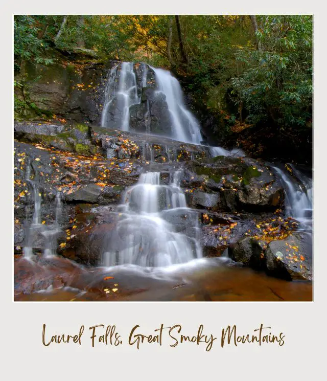
2. Laurel Falls, Great Smoky Mountains National Park
Length: 2.4 miles | 3.8 km
Difficulty: Moderately difficult with a few narrow paths and a 400-foot elevation gain
Trailhead: Little River Road just 3.5 miles from the Sugarlands Visitor Center toward Cades Cove on the north end (Tennessee side) of Great Smoky Mountains National Park
Another of the best Smoky Mountain hikes, the Laurel Falls Trail traverses the forest at first with lots of beautiful trees, especially in the fall when the leaves are changing color.
After a while, the trail curves to the right and follows the mountainside where to the left, you’ll see the epic mountain landscape with layers of mountains near and far. In the fall, the colors truly pop! This is where the trail narrows though, so be careful here as you admire the scenery.
After a couple of miles, you’ll reach Laurel Falls, arguably the best waterfalls in Smoky Mountain National Park. The magnificent waterfall is 80 feet high and surrounded by trees. There is a bridge that passes over the waterfall so you can get very close to take photos. If you are able, you can also climb down the rocks to the base of the waterfall to get a more full view of the falls.
Insider Tips:
‼️ Parking and the trail can get very crowded, especially during peak hours of the day, so to avoid crowds, visit first thing in the morning.
‼️ Although the path is paved, it is not well maintained so it still may not be suitable for wheelchairs or strollers.
Highlights:
✴️ A stunning 80-foot waterfall
✴️ Gorgeous mountain views
Recommended by By Alanna Koritzke from Periodic Adventures
3. Mount Cammerer via the Appalachian Trail
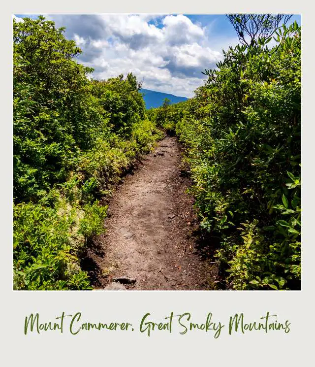
Length: 14.5 miles | 23.2 km
Difficulty: Difficult. It has 4,500 feet of elevation gain
Trailhead: Park at Pigeon River in the pull-off where the Appalachian Trail crosses the road just off I-40. If you reach the rafting company, you’ve gone too far. Many guides say to park at Davenport Gap, which cuts 4 miles off the distance, but car break-ins are a serious risk.
There’s an easier way to Mount Cammerer from Cosby, TN (this is still 11.1 miles / 17.9 km and difficult), but the long hike up on the Appalachian Trail on the NC side is one of my favorite Great Smoky Mountains trails.
The first two miles are rolling hills alongside a pretty stream. Once you reach Davenport Gap, the climb begins in earnest – a straight-up, steep, 5-mile climb. You’ll start to catch views around mile 4.5.
At Mile 6.5 you’ll reach the turnoff to the summit of Mount Cammerer. A half-mile trail takes you to the lookout tower built by the Civilian Conservation Corps. On a clear day, you can see all the way into the Plott Balsam range in NC. Return the way you came.
Mt. Cammerer’s relatively low elevation means you have a good chance of fog-free views. Check the weather at Big Creek and if it’s clear there, it’ll probably be clear (if 10 degrees colder) at the summit.
Insider Tips:
‼️ Bring trekking poles for this hike – the descent is brutal on your knees. (My favorite hiking poles are these Leki Jannu trekking poles. They’re lightweight, have shock absorbers, and have comfortable natural cork grips. You can read my detailed review here. ➡️ Check prices on Amazon here or on REI here– James).
‼️ Watch out for rattlesnakes in the rockier sections.
Highlights:
✴️ Panoramic views from an early-20th-century lookout tower
✴️ You’ll hardly see another person until you reach the side trail to the summit
✴️ Good chance of seeing bears, rattlers, deer, wild hogs, and endangered salamanders
Recommended by Carrie Mann from Train, Planes and Tuk Tuks
4. Charles Bunion Trail (off the Appalachian Trail)
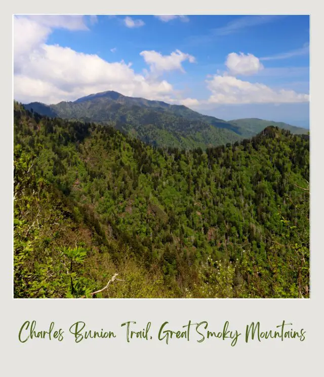
Length: 8 miles | 12.9 km
Difficulty: Difficult. It has a 1,640 feet elevation gain
Trailhead: Park at the New Found Gap overlook. You will find the beginning of the hike to the left of the overlook, at the end of the parking lot near the restrooms.
Charlies Bunion is an epic hike down the Appalachian Trail (keep walking east on this trail and you can end up in Maine). This is not a hike for beginners – the climb is steep and rocky – but the views are a fantastic reward!
Although one of the hardest hikes in the Smokies, the hike to Charlies Bunion is easily one of the best hiking trails in Smoky Mountains. If you are bold enough to try it, you will be rewarded with extraordinary panoramic views of the Smokies.
This is a challenging hike, to say the least, but worth it in the end. It is a steady climb at the beginning of the hike, with some hidden views of the Smokies.
Follow the Appalachian Trail signs for the first six miles, you will then come across a sign for Charlies Bunion. From that time on, you will start a sharp descent. This was the hardest part of the hike, there and back. But once you are past this, relax at the overlook!
Insider Tips:
‼️ Bring plenty of water! Plus a small snack to boost your energy for the way back.
‼️ Wear layers. You will get warm as you are hiking, but due to the elevation gain, it is a bit cool at the overlook.
‼️ Schedule plenty of time for this hike and do not rush it!
Highlights:
✴️ Epic views of the Smokies!
✴️ Bragging rights to say you have hiked part of the Appalachian Trail.
Recommended by Emily Dalton from Dalton’s Destinations
5. Grotto Falls, Great Smoky Mountains
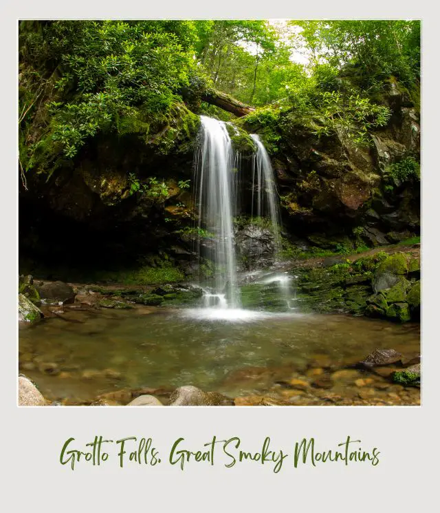
Length: 1.4 Miles One-way
Difficulty: Easy to Moderate ** this is one of the most kid friendly hikes Smoky Mountains has**
Trailhead: Trillium Gap Trailhead on the Roaring Fork Motor Trail
My pick of the best hikes in Smoky Mountain National Park is Grotto Falls. Located about 4 miles outside of Gatlinburg along the Roaring Fork Motor Trail, Grotto Falls has the distinction of being the only one of the waterfalls in Great Smoky Mountains National Park that you can hike behind.
This is one of the best easy hikes Smoky Mountains has. From the Trillium Gap Trailhead, you’ll follow a well-trodden path through an old-growth forest full of eastern hemlocks. The trail is flat, but there are a lot of exposed tree roots, so make sure to watch your footing.
After about 1.2 miles you’ll reach a small cascade that has a small swimming hole below it – perfect for cooling off if you’re hiking in the summer. And just after this small waterfall, you’ll reach the 25-foot-tall Grotto Falls.
When you’re hiking behind the falls be aware that the tricks can be quite slippery due to the spray of the waterfall.
As an added bonus, this trail is also used by llama trains that carry supplies to the Mount LeConte lodge so if you’re lucky you might spot a bunch of super cute llamas along your hike.
Once you’re finished enjoying Grotto Falls you’ll return to your car the way you came. This is one of the best waterfall hikes in the national park and is very popular so it’s best to go early to beat the crowds.
To get back to Gatlinburg you’ll continue driving along the Roaring Fork Motor Trail. Along the second half of your drive, you’ll pass by mountain settlements from the time before the national park was established. You can visit well-preserved log cabins, grist mills, and a church if you care to stop.
Insider Tip:
‼️ The parking lot at the Trillium Gap Trailhead is small so make sure you go early to be sure you can find a park spot. If you park your vehicle at any parking space in the national park for more than 15 minutes, you need a parking tag. Check the NPS website for details.
Highlights:
✴️ Grotto Falls is the only waterfall in the Smoky Mountains that you can hike behind!
✴️ Keep an eye out for the llama trains that use this trail to carry supplies up to the lodge at Mount LeConte
Recommended by Nick and Val from the Wandering Wheatleys
6. Shuckstack Fire Tower (via the Appalachian Trail)
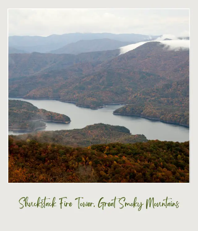
Length: 7 miles | 11/3 km
Difficulty: Strenuous
Trailhead: Fontana Dam, NC
The Shuckstack Fire Tower in the Great Smoky Mountain National Park was built in the 1930’s to serve as a lookout tower for fires. Since then, technology has evolved and most of the old fire towers have been torn down.
Shuckstack Fire Tower is one of the few remaining towers in the National Park and you can hike to it! The view from the top is amazing, which is why I think this is one of the best trails in Smoky Mountains National Park.
The best way to hike to the Shuckstack Fire Tower is via the Appalachian Trail. While there are thousands of different places to access the Appalachian Trail, if you want to do a day hike, you will want to start at Fontana Dam.
To access the trail, drive across Fontana Dam and stay to the right. You will come to a dead end. Where the road ends, the trail begins. There are two different trails so be sure to take the Appalachian trail on the left.
Once you reach the trail, you will begin the difficult hike up to Shuckstack Fire Tower.
While the tower is only 3.5 miles away from the starting point, you will gain over 2,000 feet in elevation. Around mile 3.4, there will be a fork in the trail. The Appalachian Trail will continue to the left but to get to Shuckstack Fire Tower, stay to the right until you reach the tower.
Inside Tips:
‼️ Wear solid hiking boots. The trail is rocky and it is easy to roll an ankle. (If you need to buy some good hiking shoes or boots, read my Guide to the best Hiking Shoes/ Boots ~ James)
‼️ Wear layers. The top of Shuckstack Fire Tower is chilly.
‼️ Use common sense. Don’t climb the tower if you do not feel safe. The tower is no longer maintained by the National Park Service and may not be safe.
‼️ Watch for black bears and take bear spray or a bear bell with you just in case you encounter one. Get bear spray here and a bear bell here.
Highlights:
✴️ The historic fire tower
✴️ Some of the best views in Smoky Mountain National Park
✴️ Hiking part of the Appalachian Trail
Recommended by Gabby Abbott from Journey to the Destination
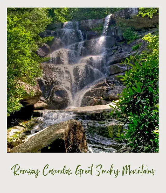
7. Ramsey Cascades, Great Smoky Mountains National Park
Length: 8 miles | 12.9 km round-trip
Difficulty: Moderate
Trailhead: Greenbrier section of the park
This is one of the classic Smoky Mountain National Park hikes and an easy pick for one of the best waterfall hikes in the Smokies. The trail takes you past towering, old-growth trees and burbling brooks up to a beautiful waterfall tucked into a rocky overhang.
There are a few creek crossings, narrow log bridges, and small sections of rocky steps, but anyone who hikes regularly and does not have mobility issues will be able to tackle this hike if they start early enough in the day. The first mile and a half can be deceiving, following an old logging road, but shortly after you’ll hit the heavily treed trail.
While there is over 2000 feet in elevation gain, it feels relatively gentle through a slow incline with only the last stretch registering some steeper, vertical rock scrambles (no special equipment required, just sturdy shoes). It’s well worn and easy to follow; keep your eyes open for wildflowers in spring!
Insider Tips:
‼️ Don’t attempt to climb above the waterfall ever or cross over at the base if the water is high. Deaths have occurred here.
‼️ Pack water, food, and bring a paper map or download a digital map before you head out. You can pick up National Geographic’s topographic day hikes maps here.
‼️ The trailhead parking lot is not huge so get to the trail early to avoid crowds; there are no trash cans or restrooms at the trailhead so pack out what you bring and plan accordingly.
Highlights:
✴️ See the highest waterfall in the Great Smokies National Park on this beautiful moderate hike.
✴️ Cross classic log bridges, rock hop, and listen to the river as you hike through tall poplar trees and mossy rocks.
Recommended by Stephanie Woodson from Explore More Clean Less
8. Chimney Tops Trail, Smoky Mountains

Length: 4.5 miles/ 7.2 km
Difficulty: Strenuous. It’s a steep trail with an elevation change of 1,400 feet.
Trailhead: 6.7 miles south from Sugarlands visitor Center on Newfound Gap Road or 22 miles north from Oconaluftee Visitor Center. Look for a parking area on the west side of the road between the lower tunnel and “the loop”. There is also very limited roadside parking.
This is one of the most legendary Great Smoky Mountains National Park hiking trails. Rated by AllTrails as the second-best hike in the Great Smoky Mountains National Park, Chimney Tops Trail lives up to its reputation.
The hike begins off the scenic Newfound Gap Road and continues on relatively flat terrain for 0.4 miles, crossing three creeks and going through an open area called Beech Flats. Then the real hike starts with 1,358 feet of elevation gain in about 2 miles.
Hikers are greeted by hundreds of man-laid wooden steps, going upward alongside a steadily flowing stream that creates a peaceful echo off the thousands of trees, for about a half-mile. After getting through the steps, which is the most strenuous part of the hike, the trail transforms into long switchbacks with wide openings to view the bottom of the trail.
Continue further and hikers are welcomed by a wide open view of the Smokies that spans for miles. Although the chimney top portion was shut down by a fire and is inaccessible to hikers, the views at the section below are worth the effort. This is one of the best views in Great Smoky Mountains National Park!
Insider Tips:
‼️ This is a popular trail and the parking area fills up quickly. Get there before 9:00am or try late afternoon.
‼️ Bring a swimsuit in summer for a post-hike cool off in natural swimming hole
‼️ Many people hike up for the sunset. If you do this, make sure you descend the rock scramble before it gets dark. Take a headlamp in case you end up walking in the dark. If you need a headlamp, you can get one here.
Highlights:
✴️ #2 hike in GSMNP
✴️ Incredible panoramic views at top
✴️ Natural swimming hole at trailhead
Recommended by Jarrod Heil from Ramble Around the World
Before you set out on these hikes, you will want to make sure you have the right gear.
➡️ Day Hike Essentials (Packing List)
➡️ Hiking Gear for Beginners (Packing List)
➡️ Best Hiking Shoes / Boots (Reviews and Recommendations)
➡️ Best Hiking Sandals (Reviews and Recommendations)
➡️ Best Winter Hiking Boots for Men (Reviews and Recommendations)
➡️ Best Winter Hiking Boots for Women (Reviews and Recommendations)
➡️ Best Baby Hiking Backpack Carrier (Reviews and Recommendations)
➡️ Best Backpack Carrier to Take Your Dog Hiking (Reviews and Recommendations)
➡️ Best Handheld GPS for Hiking (Reviews and Recommendations)
➡️ Best Microspikes for Winter Hiking (Reviews and Recommendations)
➡️ Best Snowshoes for Beginners (Reviews and Recommendations)
Happy hiking!
More Planning Resources for Great Smoky Mountains National Park
⭐ Great Smoky Mountains National Park Guide
⭐ Planning A Trip to Great Smoky Mountains National Park: 7 Mistakes to Avoid
⭐ 10 Tips For Visiting Great Smoky Mountains National Park
⭐ How to Get to Great Smoky Mountains National Park
⭐ The Best Airports Near Great Smoky Mountains National Park
⭐ The Nearest Airport to Great Smoky Mountains National Park
⭐ Best Time to Visit Great Smoky Mountains National Park
⭐ Visiting Great Smoky Mountains National Park: What To Expect Throughout the Year
⭐ 10 Fun Facts about Great Smoky Mountains National Park
What’s your favorite Smoky Mountains hiking spot (or which of these Smokies trails can you not wait to try)? I’d love to know. Join my private Facebook group National Parks Collectors and comment and let me know.
Subscribe to daily national parks planning tips, travel inspiration and trip ideas and get instant access to the free PDF of this
Best Hikes in Great Smoky Mountains National Park
If you liked this article, Pin It to your National Parks board!


💡 Are you just starting to think about taking a national parks trip? Get Inspiration
‼️ Are you looking for helpful tips for visiting US national parks? Read articles that share useful tips on a range of national-park related issues
💻 Are you starting to plan a trip to Great Smoky Mountains National Park? Read my Guide to Great Smoky Mountains National Park
🛏️ Are you looking for a place to stay near Great Smoky Mountains National Park? Find an Airbnb near Great Smoky Mountains National Park
💲 Are you ready to book your trip? Use these Planning and Booking Resources
📖 Do you want to read a book about US national parks? Check out my Recommended Reading Lists
About the Author

James Ian is a national park, camping and hiking expert.
He has dedicated his life to travel, visiting more than 80 countries, all 7 continents and most of the national parks in the United States. With over 35 years experience in the travel industry, James has worked on cruise ships, at resorts and hotels, and as a travel planner who’s helped hundreds of people plan successful trips to US national parks.
Based on his experience visiting our national parks multiple times, in-depth research and expertise as a travel planner, James has published detailed itineraries for many of the major national parks in the US. These itineraries, as well as in-depth park guides, and other resources will help you have your own incredible trip to US national parks without stress and hassle.
As a national park expert, James has contributed to many publications, including USA Today, Newsweek, Time Business News, Savoteur, Best Trip, and Wired.
I’m a member of the Amazon Services LLC Associates Program. As an Amazon Associate I earn from qualifying purchases.
